Matunga (Marathi: माटुंगा) is an upmarket locality in the heart of Mumbai City in midtown -South Mumbai . Its station is called Matunga Road on the Western line and King's Circle, (officially named, Maheshwari Udyan) on the Harbour Line.
History[]
Matunga was among the first planned localities of Mumbai. The Dadar -Matunga -Wadala -Sion plan of 1899-1900 was formulated to evenly distribute population as well as provide better living standards.Matunga today houses high-rises and cafes. Five Gardens and Adenwala, as well as the formerly known Vincent Road that further connects downtown Mumbai are primordial and famous. Matunga has a juxtaposition of Irani cafes and Udupis and houses one of the oldest residents of Mumbai. The Parsi and Gujrati communities dominate Matunga. Once home to several film stars before the advent of Bandra , Matunga still houses the old town charm of Mumbai. Geographically it is a ten minute drive from High Street Phoenix and Worli Sea Face and twenty minute drive from Mumbai CST . Matunga formed a part of the seven original islands of Mumbai with Mahim (then known as Mahikavati). Mahim.
Transportation[]
Rail[]
Bus[]
Road[]
Ferry[]
Air[]
Social Infrastructure[]
Education[]
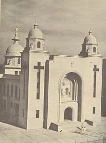
In 1937, the general council of Salesians of Don Bosco approved a plan to buy 60,000 square yards (50,000 m2) land in Matunga from the Bombay Municipal Corporation. The Corporation approved the sale on July 16, 1937. The Salesians bought the land for Rs. 229,160. The Don Bosco High School (formerly known as The Catholic Educational Institute) run by them was shifted from the rented premises at Tardeo to the new Don Bosco camp.